Noe Slow Street Proposed Changes
Muni Equity Working Group - May 16, 2024 Agenda
Muni Equity Working Group - May 16, 2024 Presentation
Potrero Yard Modernization Project Working Group Meeting #43 Agenda
Potrero Yard Modernization Project Working Group Meeting #43 Presentation
Page Slow Street Update - May 2024
Kirkham and Ortega Street Neighborways Public Hearing Agenda
Folsom Streetscape Project - Pre-Construction Open House Boards
Noe & 15th Diversion Options
West Portal Station Safety and Community Space Improvements - Diseño de la propuesta
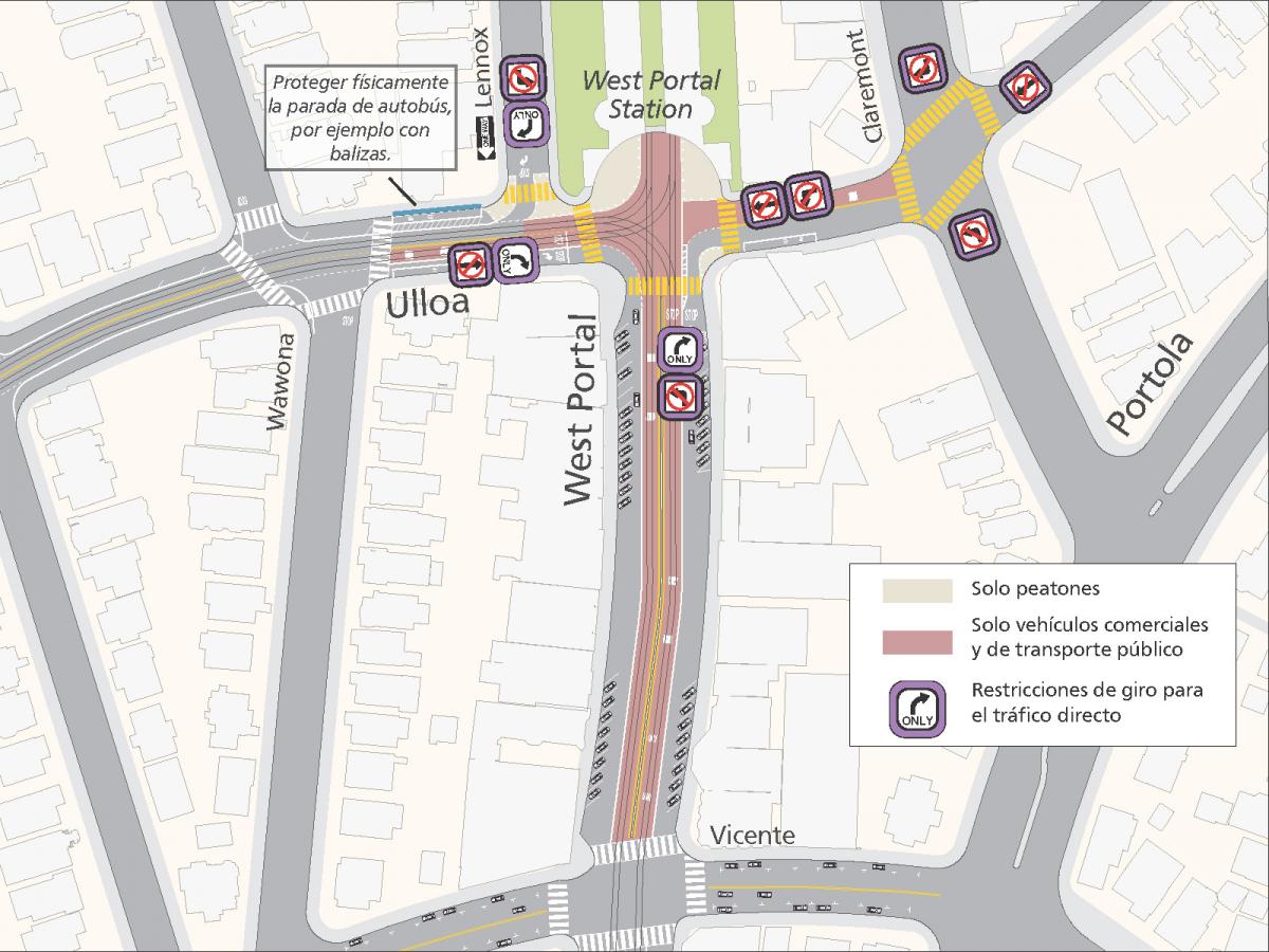
Como parte del Proyecto de Mejoras Comunitarias y de Seguridad de la Estación de West Portal, estas propuestas utilizan herramientas de probada eficacia para mejorar la seguridad del tráfico. Entre ellas figuran:
Proteger físicamente la parada de autobús del lado norte de Ulloa en Lenox, por ejemplo con balizas.
Mejorar la seguridad de la intersección al definir claramente los movimientos de los peatones, vehículos y transporte público en la intersección de West Portal Avenue y Ulloa Street. Las propuestas reducirían los conflictos entre vehículos privados, peatones y transporte público, y limitarían el tráfico de paso:
- Permitir solo giros a la derecha para los conductores que se dirijan hacia el este por la calle Ulloa en West Portal Avenue
- Permitir solo giros a la derecha para los conductores que se dirijan hacia el norte por West Portal Avenue en Ulloa Street
- Restringir el tráfico en dirección oeste en la calle Ulloa a la altura de la avenida West Portal a los vehículos de transporte público y comerciales
Añadir carriles de transporte público para alivianar los carriles disponibles para los vehículos privados, dadas las nuevas restricciones de giro.
Con las nuevas restricciones de giro en West Portal Avenue y Ulloa Street, se necesitarían menos carriles para la circulación de vehículos privados. Convertiríamos los carriles centrales de West Portal Avenue entre las calles Ulloa y Vicente en carriles de transporte público en ambas direcciones. En Ulloa Street, el carril en dirección oeste se convertiría en carril de transporte público entre Claremont Boulevard y Lenox Way, y el carril central en dirección este entre Wawona Street y West Portal Boulevard se convertiría en carril de transporte público. Los vehículos privados y comerciales podrían seguir utilizando los carriles derechos de West Portal Avenue. Estos cambios también podrían disuadir los estacionamientos en doble fila.
Convertir a Lenox Way en una calle de sentido único hacia el sur y estrechar la intersección para que los conductores solo puedan girar a la derecha en Ulloa Street.
Este cambio reduciría los riesgos de dos giros a la izquierda a lo largo del concurrido paso de peatones a través de Lenox Way directamente fuera de la West Portal Branch Library. Al convertir Lenox Way en una calle de sentido único hacia el sur, los conductores de Ulloa Street ya no podrían girar hacia Lenox Way. Además, aunque el giro a la izquierda ya es ilegal para los conductores en dirección sur en Lenox Way a la altura de Ulloa Street, los nuevos postes de giro suave estrecharían la intersección y dificultarían considerablemente el giro a la izquierda. Las bajadas en West Portal Elementary se preservarían y permitirían descensos en el lado este de Lenox Way para las familias que conducen en dirección sur.
Proporcionar más espacio peatonal dedicado y protegido directamente fuera de la estación de West Portal
En la entrada de la estación de West Portal, el espacio de la calle que utilizan actualmente los vehículos de operaciones de la SFMTA se convertiría en espacio peatonal y comunitario. Este espacio podría albergar murales de apoyo a la comunidad, asientos, canteros, estaciones de bicicletas compartidas u otras prioridades para apoyar el corredor comercial y el barrio en general.
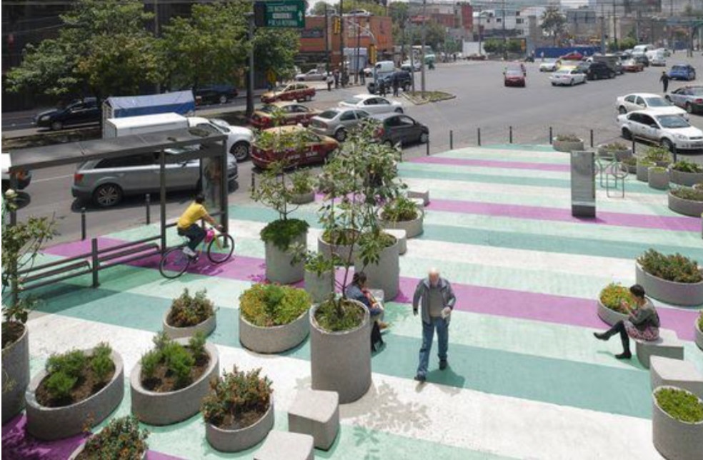
Ejemplos de materiales que podrían utilizarse para señalizar espacios exclusivos para peatones, como murales callejeros, canteros y balizas.
Modificación de la ruta del autobús 57 Parkmerced y la ubicación de una parada
La última parada entrante y la primera saliente del 57 Parkmerced se encuentra actualmente en la esquina suroeste de Ulloa Street y West Portal Avenue. Este espacio para paradas y escalas cruzaría la intersección de Ulloa Street, justo al este de West Portal Avenue.
La ruta también cambiaría por una cuadra. Los nuevos viajes entrantes comenzarían prestando servicio en su nueva parada en Ulloa entre Claremont Boulevard y West Portal Avenue antes de girar a la derecha en Claremont Boulevard, girar a la derecha en Portola Drive, girar a la derecha en Vicente Street y girar a la izquierda nuevamente en su ruta existente en West Portal Avenue.
Modificación de la ruta del autobús 91 Owl y la ubicación de una parada
Actualmente, el autobús 91 Owl realiza su parada final directamente fuera de la estación de West Portal antes de su período de escala allí. Dado que la ubicación de esa parada se convertiría en un espacio comunitario, la ubicación de la escala y la parada de la última entrada y la última salida se movería a la parada de la línea 48 Quintara-24th Street en West Portal Avenue y Ulloa Street.
Además, el autobús 91 Owl ya no daría la vuelta justo enfrente de la estación de West Portal. Los nuevos viajes de ida comenzarían en su nueva parada en West Portal Avenue y Ulloa Street antes de girar a la derecha en Claremont Boulevard, girar a la derecha en Portola Drive, girar a la derecha en Vicente Street y girar a la izquierda de nuevo a su ruta existente en West Portal Avenue.
Obtenga más información sobre los próximos eventos y comparta su opinión en nuestra encuesta antes del domingo 28 de abril.
Curbside EV Community Webinar Presentation
Speed Safety Camera Factsheet
Geary Community Advisory Committee Meeting Materials - April 10, 2024
Geary Community Advisory Committee Meeting Minutes - April 10, 2024
Potrero Yard Modernization Project Working Group Meeting #42 Minutes
Potrero Yard Modernization Project Working Group Meeting #42 Presentation
Accessible version of Geary Boulevard Improvement Project timeline infographic
Graphic showing construction schedule for the Geary Boulevard Improvement Project.
- Outreach began before 2023 and continues throughout the duration of construction.
- Quick-build transit and safety treatments by the SFMTA began in Fall 2023 and lasted for a few months. This included bus lanes, bus stop changes, pedestrian safety treatments, and roadway striping changes.
- Utility upgrades by the SFMTA are planned to begin in early 2025 and last until mid-2027. This includes water main replacement from 32nd Avenue to Stanyan; sewer main replacement from 31st to 24th and 14th to Stanyan; and fiber optic cable conduits from 25th to Stanyan.
- Major transit and safety improvements by the SFMTA are planned to begin in late 2026 and last until late 2027. This includes bus bulbs, pedestrian bulbs, upgraded traffic signals, roadway repaving, and community enhancement (treatment TBD)
Potrero Yard Modernization Project Bus Facility Updated Local Business Enterprise (LBE) Plan, March 2024
The SFMTA and Potrero Neighborhood Collective (PNC) are pleased to announce that the updated Local Business Enterprise (LBE) Plan for the Potrero Yard Bus Yard Infrastructure Facility has been posted. Visit here to view the updated LBE Plan.
The LBE Plan includes the approach to LBE participation for the Bus Yard. It also outlines the expectations that PNC (the Lead Developer) and its Design-Builder will need to adhere to for LBE compliance purposes. The updated LBE Plan for the Bus Yard was developed following feedback received on the draft LBE Plan during the comment period from January 12–29, 2024. Thank you for your input. If you have questions about the LBE Plan, please reach out to SFMTA Contract Compliance Office at PotreroYard@SFMTA.com or PNC LBE Liaisons at PotreroYard@plenaryamericas.com.
Office of Economic and Workforce Development Folsom Street Small Business Resource Guide
Survey
Automated Speed Enforcement (ASE) System Use Policy and Impact Reports
The Speed Safety System Use Policy and Impact Reports shall be made available for public review, including, but not limited to, by posting it on the designated jurisdiction’s internet website at least 30 calendar days prior to adoption by the governing body of the designated jurisdiction.
Potential Automated Speed Enforcement Camera Locations
Interactive Web Map of Potential Automated Speed Enforcement Locations:
The web map combines various data points used for the methodology in proposing 33 initial automated speed enforcement cameras in San Francisco. For more information on the program, visit the Speed Camera project page.
Potential Automated Speed Enforcement Locations:
|
ID |
District |
Street Segment |
Posted Speed Limit |
85th Percentile Speed |
Number of Daily Vehicles > 10 MPH Over Posted Limit |
Percentage of Daily Vehicles > 10 MPH Over Posted Limit |
Reasoning for ASE |
|
1 |
1 |
Fulton from 43rd Avenue to 42nd Avenue |
30 |
34 |
450 |
3.1% |
|
|
2 |
1 |
Fulton from 2nd Avenue to Arguello |
30 |
35 |
1110 |
4.5% |
|
|
3 |
1 |
Geary from 7th to 8th Avenue |
25 |
35 |
4440 |
14.2%
|
|
|
4 |
2 |
Bay from Octavia to Gough |
25 |
32 |
1010 |
5.8% |
|
|
5 |
2 |
Franklin from Union to Green |
25 |
26 |
100 |
0.7% |
|
|
6 |
3 |
Columbus from Lombard to Greenwich |
20 |
29 |
1340 |
11.3% |
|
|
7 |
3 |
Broadway from Powell to Stockton |
20 |
28 |
1920 |
8.5% |
|
|
8 |
3 |
Embarcadero from Green to Battery |
30 |
36 |
1140 |
5.6% |
|
|
9 |
4 |
Lincoln from 27th to 28th Avenue |
30 |
38 |
1890 |
9.2% |
|
|
10 |
4 |
Sloat from 41st to Skyline |
35 |
41 |
920 |
6.3% |
|
|
11 |
5 |
Geary from Webster to Buchanan |
30 |
34 |
660 |
2.9% |
|
|
12 |
5 |
Turk from Van Ness to Polk |
20 |
25 |
310 |
4.9% |
|
|
13 |
6 |
Mission from 8th to 9th Street |
20 |
29 |
1690 |
11.8% |
|
|
14 |
6 |
7th Street from Harrison to Folsom |
25 |
30 |
650 |
4.2% |
|
|
15 |
6 |
10th Street from Harrison to Folsom |
25 |
31 |
1150 |
5.5% |
|
|
16 |
6 |
9th Street from Bryant to Harrison |
25 |
30 |
680 |
3.4% |
|
|
17 |
6 |
Harrison from 4th to 5th Street |
25 |
36 |
2330 |
24.7% |
|
|
18 |
6 |
Bryant from 2nd to 3rd Street |
25 |
35 |
2030 |
15.4% |
|
|
19 |
6 |
King Street (NB only) from 4th to 5th Street |
30 |
36 |
1040 |
6.1% |
|
|
20 |
7 |
Ocean Avenue from Frida Kahlo to Howth |
25 |
27 |
340 |
1.8% |
|
|
21 |
7 |
Monterey from Edna to Congo |
25 |
35 |
2580 |
16.6% |
|
|
22 |
8 |
Market Street from Danvers to Douglass |
30 |
37 |
870 |
7.8% |
|
|
23 |
8/9 |
Guerrero from 19th to 20th Street |
25 |
29 |
520 |
3.0% |
|
|
24 |
8 |
San Jose Avenue from 29th to 30th Street |
30 |
33 |
420 |
2.0% |
|
|
25 |
9 |
16th Street from Bryant to Potrero |
25 |
28 |
340 |
2.9% |
|
|
26 |
9 |
Cesar Chavez from Folsom to Harrison |
25 |
30 |
750 |
4.4% |
|
|
27 |
10 |
Cesar Chavez from Indiana to Tennessee |
25 |
35 |
4320 |
21.2% |
|
|
28 |
10 |
3rd Street from Key Avenue to Jamestown Avenue |
25 |
29 |
350 |
4.0% |
|
|
29 |
10 |
Bayshore Blvd from 101 off-ramp to Tunnel Ave |
35 |
39 |
1040 |
3.8% |
|
|
30 |
11 |
Geneva from Prague to Brookdale |
35 |
42 |
2010 |
10.1% |
|
|
31 |
11 |
San Jose from Santa Ynez to Ocean Ave |
25 |
33 |
330 |
7.8% |
|
|
32 |
11 |
Mission from Ottawa to Allison |
20 |
30 |
1520 |
17.2% |
|
|
33 |
11 |
Alemany from Farragut to Naglee |
35 |
44 |
1960 |
14.8% |
|