Note: The Geary Rapid Project was completed in fall 2021. Learn more on the Geary Rapid Project webpage.
Frequently Asked Questions
1. What changes and amenities are coming to bus stops?
There are two types of bus stop changes:
- Some closely spaced bus stops have been removed or consolidated to improve travel time reliability.
- One bus stop will be moved from the near side of the intersection to the far side so that buses aren’t delayed by red lights as often.
You can learn more about bus stop changes by visiting the bus stop changes webpage.
Bus stop amenities within the project limits will be upgraded to include new easier-to-read bus stop signs and, where possible, real-time information displays and shelters at stops that do not already have them. Decorative brick edging will also be installed at new transit bulbs.
2. Are cars allowed to enter transit-only lanes?
San Francisco's transit-only lanes are generally only for buses, taxis and emergency vehicles, but people driving are allowed to enter side-running transit lanes to make right turns, enter driveways or enter and exit curbside parking spaces next to the lane. Red transit lanes are often dashed approaching intersections to make it easier to identify a good location to enter the lane before making a turn. Learn more about how to safely navigate transit-only lanes.
3. How will new transit-only lanes be enforced?
Muni buses are equipped with dashboard cameras that can cite parked vehicles in transit-only lanes. However, moving violations cannot be cited due to state law, so enforcement will rely on traditional methods.
4. Could Geary be upgraded to rail service in the future?
Geary’s high-transit ridership makes it suitable for rail. In fact, rail under Geary Boulevard and 19th Avenue is identified as a priority in San Francisco’s ConnectSF Transit Strategy and SFMTA is currently partnering with the San Francisco County Transportation Authority on a Geary/19th Avenue Subway Study. However, major obstacles to Geary rail include the high capital cost, a scarcity of funding sources, and the scale of disruption during construction.

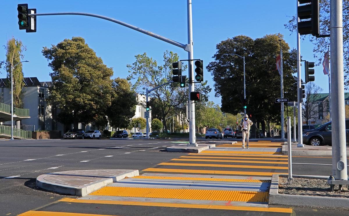
Photo shows improved crosswalk and medians at Geary and Webster.
5. How does the Geary Rapid Project improve safety and accessibility for people walking?
Prior to project implementation in 2018, a person crossing Geary was eight times more likely to be hit by a vehicle than the city average. The Geary Rapid Project aims to improve safety for people walking by redesigning intersections to make them safer, introducing new crosswalks and reducing the number of travel lanes in some parts of the corridor to calm traffic speeds.
In addition, traffic signals will be retimed and coordinated throughout the corridor to provide more time for people of all abilities to cross safely. Pedestrian countdown signals will also be added for crosswalks that do not already have them, and accessible pedestrian signals will be installed at all upgraded traffic signals. Learn more about Geary Rapid Project accessibility improvements.
6. Won’t reducing travel lanes increase traffic?
Currently, the Geary corridor has discontinuous traffic lanes. Some segments have two or three lanes, while other segments have four lanes. Cars weaving in and out of lanes contributes to congestion. A travel lane will be removed in each direction between Scott and Gough to match the number of lanes upstream and downstream, making for smoother overall traffic flow. Traffic signals will also be upgraded and retimed for improved progression.
During the environmental review process, future travel demand was estimated in order to study the impacts of removing these travel lanes. The results vary by intersection, but overall the study found that fewer total intersections would experience high levels of delay with the project than without. Many people driving would continue to drive along Geary, while a small number of drivers may choose to divert to other parallel streets.
7. What are the overall parking impacts?
Parking loss is a trade-off for better bus service and safer streets for people walking. These goals are accomplished mostly by:
- "Bus bulbs", which are sidewalk extensions at bus stops, and "pedestrian bulbs,” which extend the sidewalk at the corner of the street to shorten crossing distances for people walking.
- “Daylighting” to make people walking more visible to drivers by converting the parking space closest to the intersection to a red painted curb.
- Dedicated bus lanes along the frontage roads on Geary near Fillmore Street and Masonic Avenue.
In total, more than 98 percent of parking within one to two blocks of the corridor will be retained. Parking removal varies by block, but more than 60 percent of block faces will have no parking removal. On block faces where parking is removed, it is typically one to three spots in order to improve safety for people walking by implementing sidewalk extensions. More parking removal is necessary where there are technical constraints, but these locations are close to off-street parking garages that typically have excess capacity, such as near the Fillmore and Masonic underpasses.

8. When will construction start and how long will it last?
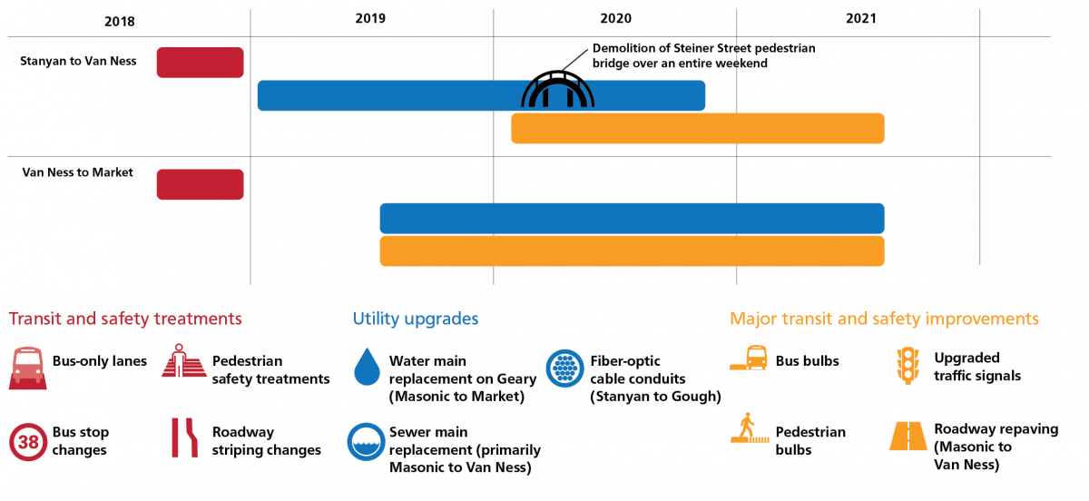
Construction began in early 2019 and concluded in fall 2021. SFMTA work, as well as coordinated work sponsored by other City agencies including roadway repaving and water and sewer main upgrades all occurred during this time period. Detailed information about the project delivery is available on our Information for Contractors page.
9. What impact to my water service should I expect during construction?
Water upgrades, coordinated with San Francisco Public Utilities Commission (SFPUC), will only affect properties that front Geary between Masonic Avenue and Market Street, and whose water service connects from Geary and not a side street. Affected properties can expect:
- Water service will be briefly shut off while SFPUC connects your service to a newly installed water main pipe.
- SFPUC will send out water shut-off notices at least 48 hours in advance of any water service interruption.
- To minimize disruption, work may be conducted at night.
10. What impact to my sewer service should I expect during construction?
None, sewer service will be maintained throughout the duration of construction.
11. Are there any benefits for people riding bikes?
Geary is a wide street and serves high traffic volumes, therefore parallel corridors (such as Post Street) are better for east-west bike routes. Geary Rapid Project bicycle improvements focus on people biking across Geary along north-south bike routes including Masonic Avenue, and Webster and Steiner streets. These improvements include green-backed sharrows in the intersection that signal the best path for cyclists to cross the street; bike traffic signals that give people biking a head start; and painting the existing sharrows on Geary between Masonic and Presidio green.
12. Will trees be removed or additional trees planted?
Within the project limits between Stanyan and Market streets, there will be three (3) trees removed throughout the entire corridor to make space for some of the improvements. However, 31 trees will be added in the vicinity where the trees will be removed, for a net addition of 28 trees. Existing trees not planned for removal will be protected-in-place during construction activities.