Noe Slow Street Proposed Changes
Muni Equity Working Group - May 16, 2024 Agenda
Muni Equity Working Group - May 16, 2024 Presentation
Potrero Yard Modernization Project Working Group Meeting #43 Agenda
Folsom Streetscape Project - Pre-Construction Open House Boards
Noe & 15th Diversion Options
West Portal Station Safety and Community Space Improvements - Proposed Design
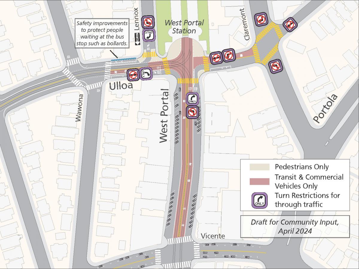
As part of the West Portal Station Safety and Community Improvements Project, these proposals use tools proven to improve traffic safety. These include:
Physically protect the bus stop on the north side of Ulloa at Lenox, such as with bollards.
Improve intersection safety by clearly defining pedestrian, vehicle, and transit movements at the West Portal Avenue and Ulloa Street intersection. The proposals would reduce conflicts between private vehicles, people walking and transit vehicles, and limit cut-through traffic by:
-
Allowing only right turns for drivers heading east on Ulloa Street at West Portal Avenue
-
Allowing only right turns for drivers heading north on West Portal Avenue at Ulloa Street
-
Restricting westbound traffic on Ulloa Street at West Portal Avenue to transit and commercial vehicles
Adding transit lanes to clarify lanes available to private vehicles given new turn restrictions. With the new turn restrictions at West Portal Avenue and Ulloa Street, fewer lanes would be needed for private vehicle travel. We would convert the center lanes on West Portal Avenue between Ulloa and Vicente streets to transit lanes in both directions. On Ulloa Street, the westbound lane would be converted to a transit lane between Claremont Boulevard and Lenox Way, and the center eastbound lane between Wawona Street and West Portal Boulevard would become a transit lane. Private and commercial vehicles could still use the right lanes on West Portal Avenue. These changes could also deter double-parking.
Converting Lenox Way to one-way southbound and narrowing the intersection to only right turns for drivers at Ulloa Street. This change would reduce the risks from two left turns through the busy crosswalk across Lenox Way directly outside the West Portal Branch Library. By converting Lenox Way to one-way southbound traffic, drivers on Ulloa Street could no longer turn onto Lenox Way. Additionally, while the left turn is already illegal for southbound drivers on Lenox Way at Ulloa Street, new soft-hit posts would narrow the intersection and make it significantly harder for drivers to turn left. Drop-offs at West Portal Elementary would be preserved by allowing for dropoffs on the east side of Lenox Way for families driving southbound.
Providing more dedicated, and protected, pedestrian space directly outside West Portal Station. At the entrance to West Portal Station, street space currently used by SFMTA operations vehicles would be converted to pedestrian and community space. This space could potentially allow for community-supporting murals, seating, planters, bike share stations or other priorities to support the commercial corridor and neighborhood at large.
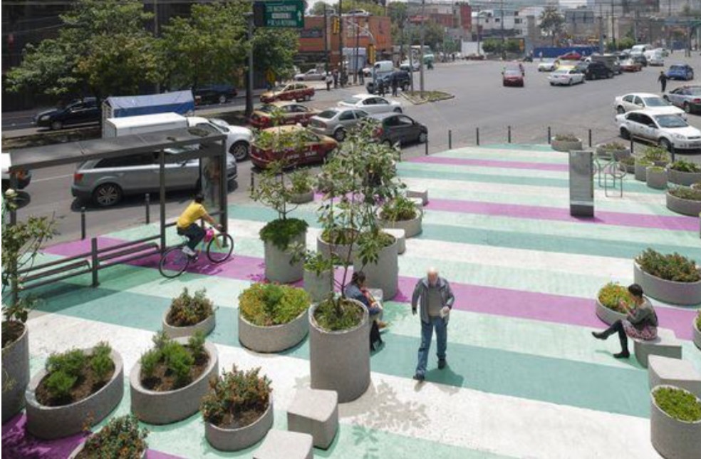
Examples of materials that could be used to mark pedestrian-only space such as street murals, planters and bollards.
Modifying the 57 Parkmerced bus’s route and one stop location.
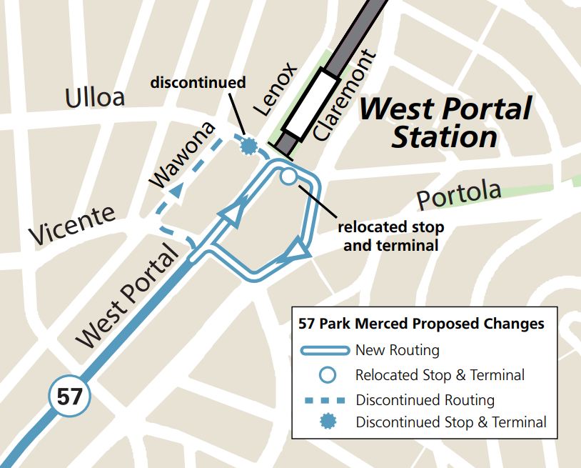
The 57 Parkmerced’s last inbound and first outbound stop is currently at the southwest corner of Ulloa Street and West Portal Avenue. This stop and layover space would move across the intersection on Ulloa Street just east of West Portal Avenue.
The route would change for one block as well. New outbound trips would begin by serving its new stop on Ulloa between Claremont Boulevard and West Portal Avenue before turning right onto Claremont Boulevard, turning right onto Portola Drive, turning right onto Vicente Street, and turning left back onto its existing route on West Portal Avenue.
Modifying the 91 Owl bus’s route and one stop location.
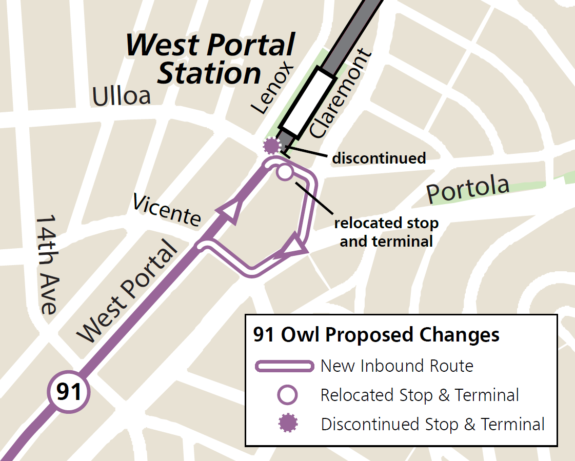
Currently, the 91 Owl serves its final stop directly outside West Portal Station before its layover period there. Since that stop location would be converted to community space, the layover location and the last inbound and first outbound stop would move to the stop used by the 48 Quintara-24th Street at West Portal Avenue and Ulloa Street.
Additionally, the 91 Owl would no longer turn around directly in front of West Portal Station. New outbound trips would begin by serving its new stop at West Portal Avenue and Ulloa Street before turning right onto Claremont Boulevard, turning right onto Portola Drive, turning right onto Vicente Street, and turning left back onto its existing route on West Portal Avenue.
Learn more are upcoming events and share your feedback in our survey by Sunday, April 28.
Geary Community Advisory Committee Meeting Materials - April 10, 2024
Geary Community Advisory Committee Meeting Minutes - April 10, 2024
Potrero Yard Modernization Project Working Group Meeting #42 Presentation
Accessible version of Geary Boulevard Improvement Project timeline infographic
Graphic showing construction schedule for the Geary Boulevard Improvement Project.
- Outreach began before 2023 and continues throughout the duration of construction.
- Quick-build transit and safety treatments by the SFMTA began in Fall 2023 and lasted for a few months. This included bus lanes, bus stop changes, pedestrian safety treatments, and roadway striping changes.
- Utility upgrades by the SFMTA are planned to begin in early 2025 and last until mid-2027. This includes water main replacement from 32nd Avenue to Stanyan; sewer main replacement from 31st to 24th and 14th to Stanyan; and fiber optic cable conduits from 25th to Stanyan.
- Major transit and safety improvements by the SFMTA are planned to begin in late 2026 and last until late 2027. This includes bus bulbs, pedestrian bulbs, upgraded traffic signals, roadway repaving, and community enhancement (treatment TBD)
Potrero Yard Modernization Project Bus Facility Updated Local Business Enterprise (LBE) Plan, March 2024
The SFMTA and Potrero Neighborhood Collective (PNC) are pleased to announce that the updated Local Business Enterprise (LBE) Plan for the Potrero Yard Bus Yard Infrastructure Facility has been posted. Visit here to view the updated LBE Plan.
The LBE Plan includes the approach to LBE participation for the Bus Yard. It also outlines the expectations that PNC (the Lead Developer) and its Design-Builder will need to adhere to for LBE compliance purposes. The updated LBE Plan for the Bus Yard was developed following feedback received on the draft LBE Plan during the comment period from January 12–29, 2024. Thank you for your input. If you have questions about the LBE Plan, please reach out to SFMTA Contract Compliance Office at PotreroYard@SFMTA.com or PNC LBE Liaisons at PotreroYard@plenaryamericas.com.
Office of Economic and Workforce Development Folsom Street Small Business Resource Guide
Automated Speed Enforcement (ASE) System Use Policy and Impact Reports
The Speed Safety System Use Policy and Impact Reports shall be made available for public review, including, but not limited to, by posting it on the designated jurisdiction’s internet website at least 30 calendar days prior to adoption by the governing body of the designated jurisdiction.
Potential Automated Speed Enforcement Camera Locations
Interactive Web Map of Potential Automated Speed Enforcement Locations:
The web map combines various data points used for the methodology in proposing 33 initial automated speed enforcement cameras in San Francisco. For more information on the program, visit the Speed Camera project page.
Potential Automated Speed Enforcement Locations:
|
ID |
District |
Street Segment |
Posted Speed Limit |
85th Percentile Speed |
Number of Daily Vehicles > 10 MPH Over Posted Limit |
Percentage of Daily Vehicles > 10 MPH Over Posted Limit |
Reasoning for ASE |
|
1 |
1 |
Fulton from 43rd Avenue to 42nd Avenue |
30 |
34 |
450 |
3.1% |
|
|
2 |
1 |
Fulton from 2nd Avenue to Arguello |
30 |
35 |
1110 |
4.5% |
|
|
3 |
1 |
Geary from 7th to 8th Avenue |
25 |
35 |
4440 |
14.2%
|
|
|
4 |
2 |
Bay from Octavia to Gough |
25 |
32 |
1010 |
5.8% |
|
|
5 |
2 |
Franklin from Union to Green |
25 |
26 |
100 |
0.7% |
|
|
6 |
3 |
Columbus from Lombard to Greenwich |
20 |
29 |
1340 |
11.3% |
|
|
7 |
3 |
Broadway from Powell to Stockton |
20 |
28 |
1920 |
8.5% |
|
|
8 |
3 |
Embarcadero from Green to Battery |
30 |
36 |
1140 |
5.6% |
|
|
9 |
4 |
Lincoln from 27th to 28th Avenue |
30 |
38 |
1890 |
9.2% |
|
|
10 |
4 |
Sloat from 41st to Skyline |
35 |
41 |
920 |
6.3% |
|
|
11 |
5 |
Geary from Webster to Buchanan |
30 |
34 |
660 |
2.9% |
|
|
12 |
5 |
Turk from Van Ness to Polk |
20 |
25 |
310 |
4.9% |
|
|
13 |
6 |
Mission from 8th to 9th Street |
20 |
29 |
1690 |
11.8% |
|
|
14 |
6 |
7th Street from Harrison to Folsom |
25 |
30 |
650 |
4.2% |
|
|
15 |
6 |
10th Street from Harrison to Folsom |
25 |
31 |
1150 |
5.5% |
|
|
16 |
6 |
9th Street from Bryant to Harrison |
25 |
30 |
680 |
3.4% |
|
|
17 |
6 |
Harrison from 4th to 5th Street |
25 |
36 |
2330 |
24.7% |
|
|
18 |
6 |
Bryant from 2nd to 3rd Street |
25 |
35 |
2030 |
15.4% |
|
|
19 |
6 |
King Street (NB only) from 4th to 5th Street |
30 |
36 |
1040 |
6.1% |
|
|
20 |
7 |
Ocean Avenue from Frida Kahlo to Howth |
25 |
27 |
340 |
1.8% |
|
|
21 |
7 |
Monterey from Edna to Congo |
25 |
35 |
2580 |
16.6% |
|
|
22 |
8 |
Market Street from Danvers to Douglass |
30 |
37 |
870 |
7.8% |
|
|
23 |
8/9 |
Guerrero from 19th to 20th Street |
25 |
29 |
520 |
3.0% |
|
|
24 |
8 |
San Jose Avenue from 29th to 30th Street |
30 |
33 |
420 |
2.0% |
|
|
25 |
9 |
16th Street from Bryant to Potrero |
25 |
28 |
340 |
2.9% |
|
|
26 |
9 |
Cesar Chavez from Folsom to Harrison |
25 |
30 |
750 |
4.4% |
|
|
27 |
10 |
Cesar Chavez from Indiana to Tennessee |
25 |
35 |
4320 |
21.2% |
|
|
28 |
10 |
3rd Street from Key Avenue to Jamestown Avenue |
25 |
29 |
350 |
4.0% |
|
|
29 |
10 |
Bayshore Blvd from 101 off-ramp to Tunnel Ave |
35 |
39 |
1040 |
3.8% |
|
|
30 |
11 |
Geneva from Prague to Brookdale |
35 |
42 |
2010 |
10.1% |
|
|
31 |
11 |
San Jose from Santa Ynez to Ocean Ave |
25 |
33 |
330 |
7.8% |
|
|
32 |
11 |
Mission from Ottawa to Allison |
20 |
30 |
1520 |
17.2% |
|
|
33 |
11 |
Alemany from Farragut to Naglee |
35 |
44 |
1960 |
14.8% |
|
Potrero Yard Tour Waiver - Adult
Potrero Yard Tour Waiver - Minor
SFMTA Budget - Fiscal Years 2025 & 2026 Community Briefing Presentation
To establish the two-year budget, SFMTA staff develop a proposed revenue and expenditure plan for the coming two-year cycle for the Operating and Capital Budgets. The SFMTA Board of Directors discusses the budget over the course of numerous board meetings and must approve the budget in time for it to be presented to the Mayor no later than May 1of each even numbered year. The City Charter outlines formulas that determine the level of funding allocated to the SFMTA from the city’s General Fund. If the proposed budget is within the defined funding levels, the Mayor must forward the budget to the Board of Supervisors as proposed. The Board of Supervisors may allow the SFMTA budget to take effect without any action or it may reject the budget.
In order to continue providing the same level of programs and services we provide now – from Muni service to traffic control to street safety improvements – we need to raise $12.7 million in new revenue. This is because costs go up every year with inflation and the cost of living. We are considering increasing Muni fares and parking fees and fines to bridge our budget gap and want to explain our proposals to you and respond to your questions and concerns.