
Slow Streets in the Oceanview/Parkside - Outreach Summary
The goal of the SFMTA’s Slow Streets program is to provide more space for socially distant essential travel and exercise during the COVID-19 pandemic. Throughout the city, nearly thirty corridors have been implemented as a Slow Street. For more information on the Slow Streets program, click here.
The program is designed to limit through traffic on certain residential streets and allow them to be used as a shared space for people traveling by foot, scooters, skateboards, and bicycles. On these Slow Streets, signage and barricades have been placed to minimize through vehicle traffic.
- Slow Streets are temporary restrictions to through traffic.
- Residents can still drive to their homes, receive deliveries, be picked up or dropped off, and more.
- These are not full street closures, and city services like trash pickup and street sweeping will remain.
- On a Slow Street, the space in the roadway is shared between people on bikes or on foot, and people driving or riding in cars.
Potential Slow Streets in Oceanview/Parkside
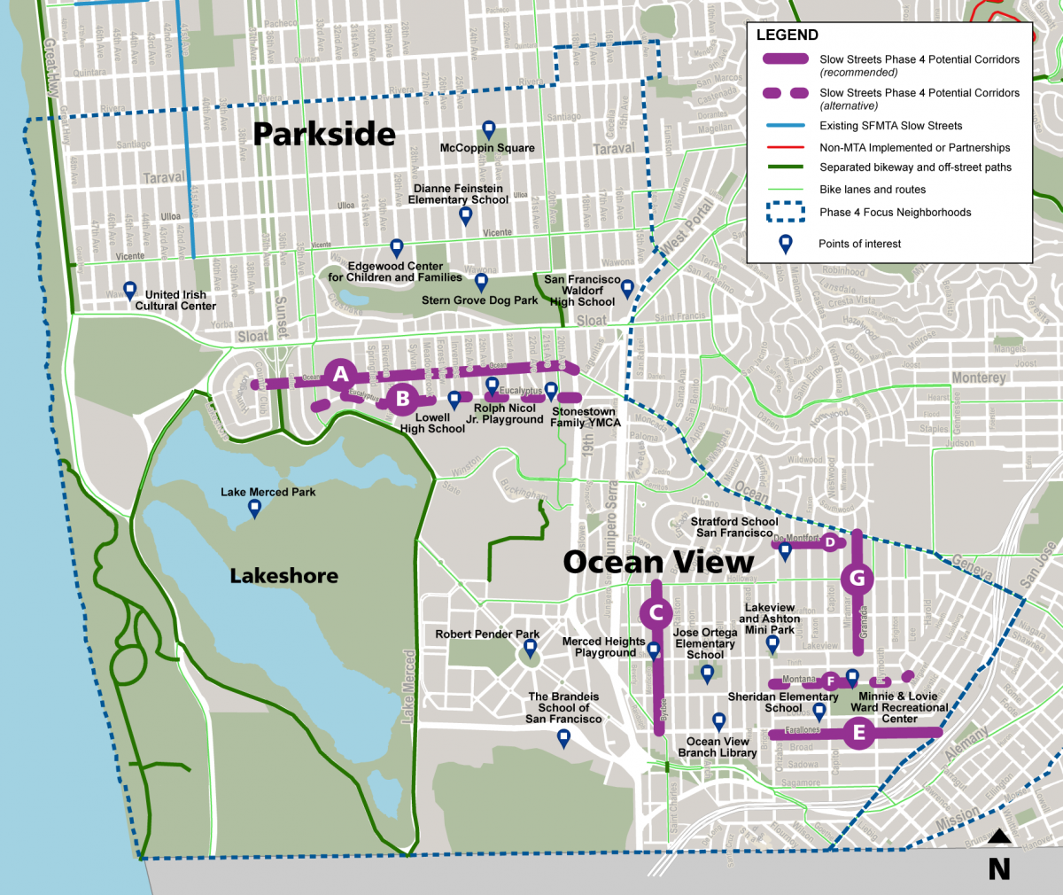
A - Ocean Avenue, from County Club Drive to 19th Avenue: Primarily residential east-west street.
B - Eucalyptus Drive, from Clearfield Drive to 20th Avenue: Primarily residential east-west street. This corridor is an alternative to Ocean Avenue.
C - Byxbee Street, from Holloway Avenue to Randolph Street: Primarily residential north-south street.
D - De Montfort Avenue, from Ashton to Miramar avenues: Primarily residential east-west street.
E - Farallones Street, from Orizaba to San Jose avenues: Primarily residential east-west street.
F - Montana Street, from Orizaba Avenue to Summit Street: Primarily residential east-west street. This corridor is an alternative to Farallones Street.
G - Granada Avenue, from Ocean Ave to Lakeview avenues: Primarily residential north-south street.
We Want to Hear from You!
12/11/2020 Update: Please note that the initial survey has been closed. The program team has reviewed the community feedback received and the outreach summary is available in the "Related Reports & Documents" section of this webpage.
We’d Love to Speak with You!
Plan to join us at one of the virtual/online/call-in events:
- Slow Streets Phase 4 Office Hours: Thursday, November 19 at 1 PM
- Slow Streets Phase 4 Office Hours: Monday, November 30 at 5 PM
- Slow Streets Phase 4 Office Hours: Wednesday, December 2 at noon
- Slow Streets Phase 4 Office Hours: Thursday, December 3 at 7 PM
Stay Informed and Involved
November 10 – December 10, 2020: Engage Oceanview and Parkside residents regarding Slow Streets.
December 11, 2020: SFMTA to review feedback and determine what corridors could become temporary Slow Streets.
December 2020 – February 2021: Review Slow Streets corridors with City agency partners (Public Works, Police, and Fire Departments) and other roadway users.
April 6, 2021: Phase 4 Slow Streets review/approval at MTA Board of Directors meeting.
Spring 2021: Install temporary traffic restrictions for Phase 4 Slow Streets.
For questions about Slow Streets, review our Frequently Asked Questions or email slowstreets@sfmta.com
Funding
This program was made possible in part by Proposition K Sales Tax dollars provided by the San Francisco County Transportation Authority.