Muni Equity Working Group - May 16, 2024 Agenda
Muni Equity Working Group - May 16, 2024 Presentation
Potrero Yard Modernization Project Working Group Meeting #43 Agenda
Potrero Yard Modernization Project Working Group Meeting #43 Presentation
Folsom Streetscape Project - Pre-Construction Open House Boards
West Portal Station Safety and Community Space Improvements - 提案設計

作為West Portal站安全和社區空間改善專案的一部分,這些提案使用經過證實可靠的工具來改善交通安全。 其中包括:
在Ulloa街與Lenox街交叉路口北側的巴士站進行物理保護,例如使用護柱。
透過明確限定West Portal Avenue和Ulloa Street交叉路口的行人、車輛和公共交通移動路線,改善交叉路口的安全。
這些提案將通過以下方式減少私家車、行人和運輸車輛之間的衝突,並限制直行交通:
- 僅允許由Ulloa Street在與West Portal Avenue的交叉路口向東行駛的司機右轉
- 僅允許由West Portal Avenue在與Ulloa Street的交叉路口向北行駛的司機右轉
- 僅限公共交通和商用車輛在Ulloa Street在與West Portal Avenue的交叉路口向西行駛
在新的轉彎限制下,新增公共交通車道以明確私人車輛可用的車道。
由於West Portal Avenue和Ulloa Street的新轉彎限制,私人車輛行駛所需的車道將減少。我們會將Ulloa街和Vicente街之間的West Portal Avenue的中間車道轉換為兩個方向的公交專用車道。在Ulloa Street,西行車道將改為Claremont Boulevard和Lenox Way之間的公交專用車道,而Wawona Street和West Portal Boulevard之間的中間東行車道將成為公交專用車道之間的中間東行車道將成為公交專用車道。私人和商用車輛仍然可以使用West Portal Avenue的正確車道。 這些改變也可能會遏制並行停車。
將Lenox Way轉換為單向南行,並將交叉路口縮小至僅限司機在Ulloa Street右轉。
這一改變將減少在West Portal 圖書館分館正外橫跨Lenox Way的繁忙人行橫道上左轉兩次的風險。透過將Lenox Way轉換為單向南行交通,Ulloa Street上的司機無法再轉向Lenox Way。此外,雖然在Ulloa Street與Lenox Way的交叉路口上,左轉對於南行司機來說已經是非法的,但新的防撞柱將使交叉路口變窄,並使司機更難左轉。 將保留West Portal 小學的下車點,並允許向南行駛的家庭在Lenox Way的東側下車。
直接在West Portal站外提供更多專用和受保護的行人空間
在West Portal站的入口,三藩市交通局 (SFMTA) 運營車輛目前使用的街道空間將轉換為行人和社區空間。 這個空間可能允許社區支持的壁畫、座位、花盆、腳踏車共享站或其他優先事項,以支持商業走廊和整個社區。
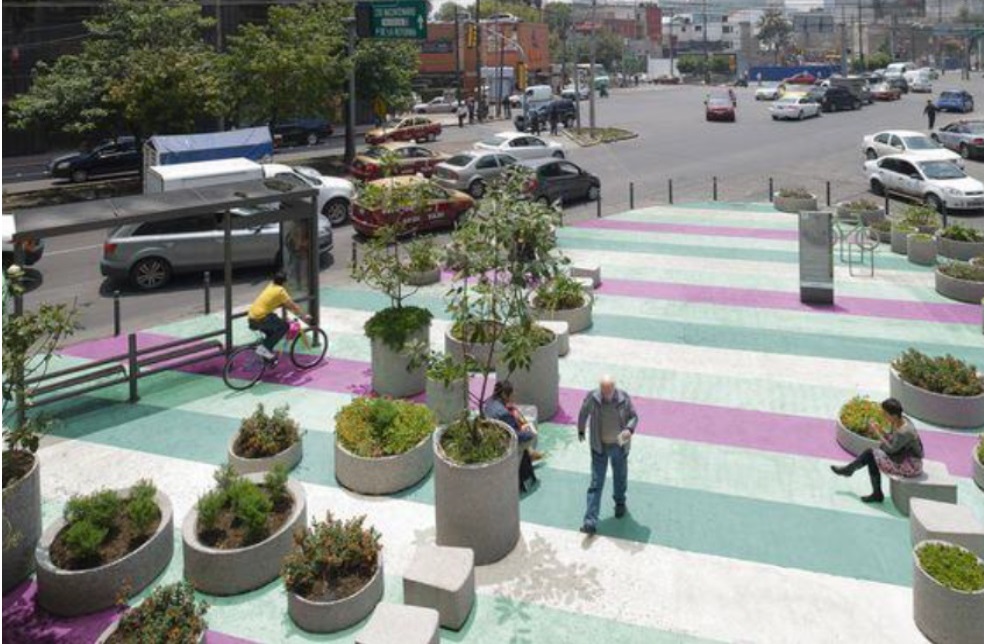
可用於標記行人專用空間的材料範例,例如街頭壁畫、花盆和護柱。
修改57 Parkmerced巴士的路線和一個停靠站地點
57 Parkmerced 的最後一個進站和第一個出站車站目前位於 Ulloa 街夾 West Portal 街的西南角。該車站和中途停留位置將移至十字路口對面的 Ulloa 街夾West Portal 街以東。
該路線的一個路段也將出現變更。新的首發站將在 Ulloa 街夾 Claremont 大道與 West Portal 街之間,然後右轉進入 Claremont 大道,再右轉進入 Portola Drive,再右轉進入 Vicente 街,然後再左轉進入現有的 West Portal 街路線。
修改91 Owl巴士的路線和一個停靠站地點
目前, 91 Owl 在West Portal站停留期間之前,直接作為在West Portal車站外最後一站 。 由於此停靠點將轉換為社區空間,因此停靠站以及最後一個入站和第一個出站 停靠站將移至 48 Quintara-24th Street在West Portal Avenue和Ulloa Street使用的停靠站。
此外,91 Owl 將不再直接在West Portal站前折返。新的下車行程將從在West Portal Avenue和Ulloa Street的新停靠站開始,然後右轉進入Claremont Boulevard,右轉進入Portola Drive,右轉進入Vicente Street,然後左轉回到West Portal Avenue的現有路線。
深入了解即將舉行的活動,並在4月28日(星期日)前接受我們的調查以分享您的意見回饋
Geary Community Advisory Committee Meeting Materials - April 10, 2024
Geary Community Advisory Committee Meeting Minutes - April 10, 2024
Potrero Yard Modernization Project Working Group Meeting #42 Minutes
Potrero Yard Modernization Project Working Group Meeting #42 Presentation
Accessible version of Geary Boulevard Improvement Project timeline infographic
Graphic showing construction schedule for the Geary Boulevard Improvement Project.
- Outreach began before 2023 and continues throughout the duration of construction.
- Quick-build transit and safety treatments by the SFMTA began in Fall 2023 and lasted for a few months. This included bus lanes, bus stop changes, pedestrian safety treatments, and roadway striping changes.
- Utility upgrades by the SFMTA are planned to begin in early 2025 and last until mid-2027. This includes water main replacement from 32nd Avenue to Stanyan; sewer main replacement from 31st to 24th and 14th to Stanyan; and fiber optic cable conduits from 25th to Stanyan.
- Major transit and safety improvements by the SFMTA are planned to begin in late 2026 and last until late 2027. This includes bus bulbs, pedestrian bulbs, upgraded traffic signals, roadway repaving, and community enhancement (treatment TBD)
Potrero Yard Modernization Project Bus Facility Updated Local Business Enterprise (LBE) Plan, March 2024
The SFMTA and Potrero Neighborhood Collective (PNC) are pleased to announce that the updated Local Business Enterprise (LBE) Plan for the Potrero Yard Bus Yard Infrastructure Facility has been posted. Visit here to view the updated LBE Plan.
The LBE Plan includes the approach to LBE participation for the Bus Yard. It also outlines the expectations that PNC (the Lead Developer) and its Design-Builder will need to adhere to for LBE compliance purposes. The updated LBE Plan for the Bus Yard was developed following feedback received on the draft LBE Plan during the comment period from January 12–29, 2024. Thank you for your input. If you have questions about the LBE Plan, please reach out to SFMTA Contract Compliance Office at PotreroYard@SFMTA.com or PNC LBE Liaisons at PotreroYard@plenaryamericas.com.
Office of Economic and Workforce Development Folsom Street Small Business Resource Guide
Automated Speed Enforcement (ASE) System Use Policy and Impact Reports
The Speed Safety System Use Policy and Impact Reports shall be made available for public review, including, but not limited to, by posting it on the designated jurisdiction’s internet website at least 30 calendar days prior to adoption by the governing body of the designated jurisdiction.
Potential Automated Speed Enforcement Camera Locations
Interactive Web Map of Potential Automated Speed Enforcement Locations:
The web map combines various data points used for the methodology in proposing 33 initial automated speed enforcement cameras in San Francisco. For more information on the program, visit the Speed Camera project page.
Potential Automated Speed Enforcement Locations:
|
ID |
District |
Street Segment |
Posted Speed Limit |
85th Percentile Speed |
Number of Daily Vehicles > 10 MPH Over Posted Limit |
Percentage of Daily Vehicles > 10 MPH Over Posted Limit |
Reasoning for ASE |
|
1 |
1 |
Fulton from 43rd Avenue to 42nd Avenue |
30 |
34 |
450 |
3.1% |
|
|
2 |
1 |
Fulton from 2nd Avenue to Arguello |
30 |
35 |
1110 |
4.5% |
|
|
3 |
1 |
Geary from 7th to 8th Avenue |
25 |
35 |
4440 |
14.2%
|
|
|
4 |
2 |
Bay from Octavia to Gough |
25 |
32 |
1010 |
5.8% |
|
|
5 |
2 |
Franklin from Union to Green |
25 |
26 |
100 |
0.7% |
|
|
6 |
3 |
Columbus from Lombard to Greenwich |
20 |
29 |
1340 |
11.3% |
|
|
7 |
3 |
Broadway from Powell to Stockton |
20 |
28 |
1920 |
8.5% |
|
|
8 |
3 |
Embarcadero from Green to Battery |
30 |
36 |
1140 |
5.6% |
|
|
9 |
4 |
Lincoln from 27th to 28th Avenue |
30 |
38 |
1890 |
9.2% |
|
|
10 |
4 |
Sloat from 41st to Skyline |
35 |
41 |
920 |
6.3% |
|
|
11 |
5 |
Geary from Webster to Buchanan |
30 |
34 |
660 |
2.9% |
|
|
12 |
5 |
Turk from Van Ness to Polk |
20 |
25 |
310 |
4.9% |
|
|
13 |
6 |
Mission from 8th to 9th Street |
20 |
29 |
1690 |
11.8% |
|
|
14 |
6 |
7th Street from Harrison to Folsom |
25 |
30 |
650 |
4.2% |
|
|
15 |
6 |
10th Street from Harrison to Folsom |
25 |
31 |
1150 |
5.5% |
|
|
16 |
6 |
9th Street from Bryant to Harrison |
25 |
30 |
680 |
3.4% |
|
|
17 |
6 |
Harrison from 4th to 5th Street |
25 |
36 |
2330 |
24.7% |
|
|
18 |
6 |
Bryant from 2nd to 3rd Street |
25 |
35 |
2030 |
15.4% |
|
|
19 |
6 |
King Street (NB only) from 4th to 5th Street |
30 |
36 |
1040 |
6.1% |
|
|
20 |
7 |
Ocean Avenue from Frida Kahlo to Howth |
25 |
27 |
340 |
1.8% |
|
|
21 |
7 |
Monterey from Edna to Congo |
25 |
35 |
2580 |
16.6% |
|
|
22 |
8 |
Market Street from Danvers to Douglass |
30 |
37 |
870 |
7.8% |
|
|
23 |
8/9 |
Guerrero from 19th to 20th Street |
25 |
29 |
520 |
3.0% |
|
|
24 |
8 |
San Jose Avenue from 29th to 30th Street |
30 |
33 |
420 |
2.0% |
|
|
25 |
9 |
16th Street from Bryant to Potrero |
25 |
28 |
340 |
2.9% |
|
|
26 |
9 |
Cesar Chavez from Folsom to Harrison |
25 |
30 |
750 |
4.4% |
|
|
27 |
10 |
Cesar Chavez from Indiana to Tennessee |
25 |
35 |
4320 |
21.2% |
|
|
28 |
10 |
3rd Street from Key Avenue to Jamestown Avenue |
25 |
29 |
350 |
4.0% |
|
|
29 |
10 |
Bayshore Blvd from 101 off-ramp to Tunnel Ave |
35 |
39 |
1040 |
3.8% |
|
|
30 |
11 |
Geneva from Prague to Brookdale |
35 |
42 |
2010 |
10.1% |
|
|
31 |
11 |
San Jose from Santa Ynez to Ocean Ave |
25 |
33 |
330 |
7.8% |
|
|
32 |
11 |
Mission from Ottawa to Allison |
20 |
30 |
1520 |
17.2% |
|
|
33 |
11 |
Alemany from Farragut to Naglee |
35 |
44 |
1960 |
14.8% |
|